Upper Dolpo Trekking
 Ba-Yul is said to be the hidden treasure of Dolpo. Few farmers and nomad settled down here in the 10th century after migrating from Tibet . You see the thick inhabitant of the people there with scattered villages and monasteries nestling among the mountains. Despite being a part of Nepal , it still culturally and economically tied to the Tibet . People are almost cut off to their southern neighbors due to the snow-covered passes. This is one of fascinating and equally difficult place to travel.
Most part of the Dolpo is preserved by the Shey Phoksundo national park. Dhaulagiri and Churen ranges lie in the east and south of Dolpo and Jumla in the west. As Dolpo is very remote part of Nepal , you can not see any signs of development there. However, the scenario is being changed due to tourism. However, few anthropologist and geographers explored this region. This region was not opened for foreigners till 1989. However, southern part of the Dolpo was opened for organized trekking groups.
Peter Matthiessen's ‘The snow leopard’ and David Snellgrove's ‘Himalayan Pilgrimage’ have contributed to the mystique and attraction of Dolpo. Both writers visited the Shey Gompa, to the north of the Phoksumdo Lake , in inner Dolpo. This is the goal of most trekkers but this Dolpo trek will take you even further into this mysterious land.
Dolpo is a Bon-pro country, where people practice a shamanistic religion predating Tibetan Buddhism.
Bon-Po symbolism is exactly opposite to the Buddhism. Therefore, you need to take some ritual practices seriously like walking right to the ancient mud chortens. This fact in more explained in the swastika sign, as it’s every arm points in the opposite direction. The Buddhist chant “Om mani padme hum” is called 'Om ma tri mu ye sa le du" in Bon-Pa. The closest translation of this is in clarity unite.
Highlight sights of Upper Dolpo Trekking:
Sisne Himal 5849m, Api Himal 7132m, Api West 7100m, , Saipal 7031m,, Rakshya Uda 6593m, Kandey Himchuli 6227m, Buraburi 5387m, Tsokalpo Khang 6556m, Wedge peak 6139m. Kangchune 6443m, Bijala Himchuli 6386m, Paltathumba 6157m, Milch Berg 5992m, Hanging Peak 6500m, Kang Peak 6224m, Yaja Peak 5962m. And Dhaulagri rage.
Facts of Upper Dolpo Trekking
| Country | Nepal |
| Trekking Destinatin: | Upper Dolpo Trekking |
| Trekking Starts in: | Juphal |
| Trekking Ends in: | Jomsom |
| Trip Duration: | 27 Days |
| Activities: | Trekking & Walking, Cultural Tours & Sightseeing |
| Culture: | Majority of Tibetan, Sherpa, Tamang, Gurung, Magar, Chhetri. |
| Transportation: | Private vehicle as per itinerary | Kathmandu - Nepalgunj -Juphal by plane, Jomsom - Phokhara - Kathmandu by plane or by bus |
| Accommodation: | 4 Nights in Kathmandu, 1 Night in Nepalgunj, 1 Night in Pokhara, 20 Nights in trekking lodge/ camping. |
| Trekking grade: | Hard |
| Max. Altitude: | 5100m (Kagmara La Pass) |
| Best season in Nepal: | Mar, Apr, May, Sep, Oct & Nov |
| Mode of Trekking: | Camping |
| Group Size: | Min 02 PAX, Max 12 PAX |
Upper Dolpo Trekking
Detail Itinerary for Upper Dolpo Trekking
| Days | Day to Day Activities |
|---|---|
| 01 |
Arrival in Kathmandu
Flying to Kathmandu along the northern border of Nepal on a clear day is in itself an exciting and memorable experience. As you fly, the panoramic view of snow-capped Annapurna mountain range greets your sight. After Visa formalities complete, you have to come downstairs to collect Luggage and proceed to outside from terminal Building. Please look after your Printed Name and Our Company Signboard Annapurna Foothills Treks & Exp follow them. Meet our Staff and then Transfer to Hotel. Check in at Hotel, free welcome drinks tea/coffee or any cold drinks. Company Managing Director or Manager will meet you and Briefing about the trip. Balance trip Payment should clear if any etc. Free day for relax or explore around the city yourself. |
| 02 |
Kathmandu
After Breakfast 9 AM your City guide come with vehicles and will brief details your plan for sightseeing tour of 4 Popular UNESCO Heritage sites of Kathmandu Valley. Our first destination is Swoyambhunath. This place offers a majestic view of the entire Kathmandu valley. Stupa of Swoyambhunath epitomizes Buddhism. Your guide will enlighten you with detailed historical and cultural information about the place. After this you will visit Living goddess home and Kathmandu Durbar square. Locally this, Old royal palace area is called Basantapur Area or Hanuman dhoka Durbar Square. Our next sightseeing will be at Boudha nath (the biggest & Largest Buddhist Stupa in the World). In this Area, you will visit Buddhist Monastery and stop for lunch Break. If weather is clear you can see nearest Mountain of Kathmandu- Ganesh Himal from top of Restaurant. After Lunch, we will visit Hindus temple Pasupatinath and tour for today is finished. It normally takes 5-6 hours tour to visit all these 4 monuments within Kathmandu city, afternoon free for packing for trek and getting ready. |
| 03 |
Fly to Nepalganj
We fly from Kathmandu to Nepalganj, which lies in the southwest part of the Terai, right on the border to India. After checking into our hotel we might visit the Bageshwari Mandir, a temple to honour Goddess Kali. Nepalganj is known for its local bazaars, which have goods with cheap price rates. Here, not only do we see people from all over Nepal, but also people from Tibet and India; they all come here for trade. |
| 04 |
Fly to Juphal [2500m], Trek to Dunai [2100m]
We take an early morning flight to Juphal. Dolpo flights are always scheduled early in the morning. This is because high winds in the Thulo Bheri Valley begin around 10 am, making later flights impossible. Once we arrive at Juphal (2500m), we start out on the short walk from Juphal to Dunai. We walk downhill through meadows and past a few houses to the small hotels at Kala Gaura (2090m). From here we follow the river trail upstream to Dunai. We camp near Dunai and explore this bustling little hill town for the rest of the afternoon. |
| 05 |
Trek to Chepka [2670m]
We start trekking from Dunai, cross the big steel suspension bridge and turn west, following the trail past the hospital, and then it's a level walk along the bank of the Thulo Bheri to its confluence with the Suli Gaad at 2070m. We follow the new trail north up the east bank of the Suli Gaad to a collection of teashops run by the wives of army personnel in Dunai. Another hour of walking takes us to Kal Rupi and then on to Raktang (2260m). We cross to the west bank and trek past numerous goths and horse pastures, over a ridge to the rough stone houses of Jyalhasa, a wintering spot for the people of Ringmo. We keep walking upstream to another bridge, cross it to the east bank, and make our way past some crude teashops and a bridge over a side stream, the Ankhe Khola, at 2460m. The trail moves up and down through grass and ferns to a trail junction. The fork is the old trail leading to the army and national park post at Ankhe, and on to the old trail that passes the villages of Rahagoan and Parela, high on the ridge above. These three villages have a strange name connection: Parela (parela means eye-lashes), Rahagoan (raha means eyebrow) and Ankhe (ankha is eye). The trail Phoksumdo Lake climbs over a ridge at 2710m then descends on a rocky path to Chepka (2670m), which is inhabited by three brothers and consists of collection of interconnected shops, rakshi stalls and lodges. We camp here or at another good spot beside a huge rock in walnut grove about 20 minutes beyond Chepka. |
| 06 |
Trek to Renje [3010m]
We continue on the new trail, which stays near the river, climbing over a small ridge ,then crossing to the west side to avoid a large ridge and returning to the east side an hour later near a national park camping ground. Alongside the river at 2900m, the trail becomes a collection of rocks and sticks forming a dyke along the river bank. The trail makes several more ups and downs through forests of firs and larches as it continues upstream to a bridge that leads to nine houses comprising the village of Renje on the opposite side of the river at 3010m. We camp at a good camp site here or another about five minutes further on. |
| 07 |
Trek to Ringmo [2650m]
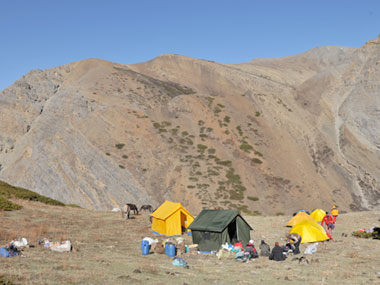
We follow the Suli Gaad valley, which turns eastward and becomes even steeper and narrower. We then climb over a ridge and descends to a wooden bridge then continue along the ups and downs along the valley floor to the confluence of the Suli Gaad with the Pungmo Khola. From here the trail to Phoksumdo Lake and Shey gompa follows the west bank of the river. We climb through a forest of big cedar to a good camp site and then on to Palam (3710m), a winter settlement used by the people of Ringmo village. The houses are almost buried in the sandy soil. The entrance station for Shey Phoksumdo National Park is at the south end of the village. After our park entrance ticket is examined, we may be subjected to a baggage inspection-ostensibly for drugs and stolen art objects. It's very peculiar formality in this remote locale. We continue on the route, which switchbacks steeply on a sandy trail through open country to an elevation of 3300m, then we start up another steep set of dusty switchbacks to a ridge at 3780m. From the ridge there are distant views of a spectacular 200m -high waterfall, the highest in Nepal. The trail makes a steep descent in birch forests to the upper reaches of the brilliantly clear, rushing waters of the Phoksumdo Khola. Then we climb gently to Ringmo village, a picturesque settlement of flat-roofed stone houses with lots of mud -plastered chortens and maniwalls. Just below Ringmo, we cross a bridge and follow a trail north to the ranger station at Phoksumdo Lake (3730). We continue to the shores of the lake near the point where the Phoksumdo Khola flows out of the lake. There are national park camping grounds on both sides of the river on the south-east shore of the lake. Park rules prohibit us from camping in other places. |
| 08 |
Rest and exploration
A trail leads from the lakeside through juniper trees to the white Pal Sentan Thasoon Chholing gompa, a ramshackle Bon-po gompa overlooking the lake that is said to have been built 60 generations ago. There are five other private gompas in various houses of small monastic community near the lake. The insides of the temples contain dusty Buddhist paintings and statues, but the trappings also reflect the animistic elements of the Bon-po religion, so some of the chapels are reminiscent of an ancient witch's cavern. A donation to the ragtag collection of dirty monks will gain us entrance to the gompas; our Sherpas will be equally fascinated by the strange iconography and practice of the Bon-po religion. |
| 09 |
Trek to Chunemba [3630m]
From our campsite near Ringmo on the southern end of Phoksumdo Lake, the trail contours on a rocky ledge as it skirts the western lip of the lake. In places it's precariously suspended on a gangway of wood supported on pegs driven into crevices in the rocks. As we cross a stream, look up at the glacier descending from the upper slopes of Kanjeralwa (6612m). We then climb to a crest at 4060m for a spectacular view of the lake with the snowy peaks of Sonam Kang in the background. The trail makes a step and dusty descent through birches and blue pines to the westernmost edge of the lake at 3630m where the Phoksumdo Khola enters. The route now heads west, up along a wide valley. We follow an indistinct trail through thorn bushes and scrub trees, crisscrossing boggy marshes and tributaries of Phoksumdo Khola. We camp in a forest of blue pines at Chunemba, an undeveloped national park camping ground at 3630m. |
| 10 |
Trek to Lar Tsa [4120m]
We begin the day along the level path that now heads north through a glacial valley. We then cross to the east bank of Phoksumdo Khola. We follow the main valley for another hour to Kang Gompa. We climb steeply from Kang Gompa and stay on the grassy ridge. It's a long climb up the ridge past a few groves of birch trees. There are spectacular mountain views with Shey Shikar (6139m) and Kang Chunne (6443m) dominating the skyline to the west. We continue on a crest at 4200m then the route descends gently on a rocky trail to Lar Tsa, a camp site besides the river at 4120m. It's possible to continue walking, but we have now ascended more than 500m in a day and should spend the night at Lar tsa for acclimatisation. |
| 11 |
Trek to Mendok Din [4610m]
We cross a new bridge and climb to the top of a scree slope at 4490m, then make our way up a grassy ridge to a crest at 4640m. We contour and then drop gently into Mendok Ding (flower valley). We again climb alongside a stream to a campsite at 4610m. You are almost certain to spot a herd of blue sheep on the slopes above the camp. |
| 12 |
Trek to Shey Gompa [4390m]
We continue on the route that follows the upper reaches of the Phoksumdo Khola, then we turn north towards the peak of Riwo Drugdra (Crystal Mountain). There is a choice of trails here; we follow the more scenic pilgrim route across the Sehu La to the west of Crystal Mountain, making a kora (circumambulation) of this sacred peak. The Dolma trail turns north soon after camp while the pilgrim trail starts up a steep scree slope on the opposite side of a stream that flows from the north. After a long pull to Sehu La (also known as Mendok Ding La) at 5160m the trail descends a scree slope to a grassy meadow besides a stream valley and begins a series of long ascents and descends across ridges in and out of side valleys as it traverses around Crystal Mountain. After a steep, rough climb to a crest at 5010m and another at 4860m, we begin the descent to the Tar valley. Soon after the route reaches grassy slopes, a side trail leads to Tsakang, a gompa said to be 800years that is perched dramatically on the side of a cliff. The final descent is on a wide trail to a campsite in a large meadow near a few huts of nomads at 4310, just below Shey gompa. |
| 13 |
Rest-Exploration
Cross the river on a log bridge and climb past a big Chorten and a huge field of mani stones to the Shey gompa compound at 4390m. The gompa itself is not large, and there are no artifacts or paintings of note inside. Although the building is said to be 800years old, the wall paintings are relatively recent, probably done in 1970s. The statues on the altar are of Guru Rinpoche, Sakyamuni and Milarepa. The gompa also houses an ancient Tibetan scroll that describes the myth of Crystal Mountain and Shey gompa. According to the inscription, there is a holy lake in a crater among the mountains that surrounds Shey. When a pilgrim makes nine circumambulations of this lake the water turns milky. A sip of this milk and the pilgrim can see Mt Kailash in the distance. The ones, who don’t need a day of rest, can try to find this lake. |
| 14 |
Trek to Namgung [4430m]
We trek east from Shey gompa and across the 5010m Shey La. Here we turn north and descend before climbing again to Namgung (4430m). |
| 15 |
Trek to Karang [4050m]
We traverse high above the Namgung Khola to Karang (4050m). It's also possible to descend to Saldang on the banks of the river, but this village is of little interest. |
| 16 |
Trek to Mugaon [4100m]
We descend to Torak Sumdo (3670m), the confluence of the Namgung and Polang kholas, and cross to the northern bank. We then climb to Yanger gompa at 3750m and trek along the river side valley. We camp at one of the campsites along the side of the stream at about 4100m before Mugaon. |
| 17 |
Trek to Shimen [4010m]
We continue up the valley to Mugaon and climb towards the Mushi La at 5030m. Then we descend towards Shimen village, we end the day at a good campsite in pastures above the village at 4010m. |
| 18 |
Trek to Tinje [4150m]
We drop down to Shimen village at 3870m and make a long trek upriver through Pha (4090m) to Tinje (4150m). |
| 19 |
Trek to Rakpa [4530m]
We trek past the runway of mysterious Tinje airport to a trail junction at 4130m, where a high route leads to Tarap. We continue southward to a campsite on the banks of the river at Rakpa (4530m). |
| 20 |
Trek to Chharka [4120m)
We begin our day with a long climb to the Chharka La (4920m). We continue on the trail descending along the side of the valley, then make a big drop into a side valley at 4290m. We then make a long traverse down to the picturesque village of Chharka on the banks of Barbung Kola at 4120m. |
| 21 |
Trek to Norbulung [4750m]
Another Climb to a crest at 4380m begins this day. We then descend again to a river. We follow the right fork southward, climbing in and out of side valleys on a rough trail. The valley narrows, we then emerge into a big meadow and climb to our campsite at Norbulung (4750m). |
| 22 |
Sangda Phedi [5460m]
We begin the day climbing to a yak pasture at Molum Sumna (4860m) and on to a crest at 5130m. We then make a long traverse across meadows to the foot of the Sangda La, then a long, steep final climb to the pass at 5460m. Switchbacks descend down to our camp site by a stream at 5100m. |
| 23 |
Trek to Sangda [3700m]
We climb to a lower Sangda La at 4990m, then descend through loose shale towards the village of Sangda Ghunsa (4190m). We drop to the Chalung Khola, crossing it at 3750m, and then climb steeply up the opposite bank. A long high traverse leads to a cairn at 4090m, we then come to a set of steep switchbacks descends to a stream at 3580m. We do another climb to the compact settlement of Sangda, were we end a long day at 3700m. |
| 24 |
Trek to Dhagarjun [3290m]
We climb the hill behind Sangda and spend most of the day making a high traverse, crossing nine ridges to a final crest at 4280m. We then descend into the Kali Gandaki valley, traversing under high cliffs and descending to the large village of Dhagarjun (3290m). |
| 25 |
Trek to Jhomson [2670m], fly to Pokhara
We climb to a ridge at 3360m and make a final descent on a challenging trail of loose rocks to Jomsom at 2670m. We take an early flight from Jomsom to Pokhara - a fantastic way to round off the trek, flying right along the Kali Gandaki Gorge between the Annapurna and Dhaulagiri ranges. In Pokhara we check into the Hotel, get the dust of the last three weeks washed off and head out for a nice dinner. |
| 26 |
Drive/Fly Kathmandu
We either take a 35 minutes flight or a six hour drive to Kathmandu. After reaching Kathmandu, you can indulge in independent activities of your choice. |
| 27 |
Depart Kathmandu
Our Nepalese support team will take you to the airport for your flight home. On the other hand, if you prefer to stay longer, you can go for short tours such as game drive at National parks, rafting, Tibet tours, mountain biking, etc. – ask us. |
Note:
The monsoon starts in July to August in Nepal. Nevertheless, there are few rain shadow areas such as Upper Mustang, Upper Manang, Rara Lake, Langtang valley, Everest Gokyo valley and Dolpo Region where we can go for trek even in monsoon. Due to the presence of huge mountains in this area, the rain cloud can’t go there and it remains unaffected by the monsoon. However, we suggest you to carry raincoat and insect repellents.
IMPORTANT NOTE:
The safety and security of clients is a matter of great importance for us. All of our trips are led by qualified professional government license holder guides and they have received adequate training from the government of Nepal. We always carry first aid kits in our trip. Out duty is to work hard for you safety and comfort, no matter where we go. Therefore, we work very honestly to provide you the Himalayan experience that suits your needs. Please feel free to put forward your queries for making your trip more significant and memorable.
Upper Dolpo Trekking Service Includes
- 4 nights hotel in Kathmandu with Bed & Breakfast and one night hotel in Nepaljung (Click for Hotel)
- Equipment: Trekking tents, Dining tent, Kitchen Tent, Toilet Tent, Table and chairs, Mattresses during the trekking
- National Park fee Upper Dolpo Special Permit.
- Food: Food for trekking (Breakfast, lunch, dinner)
- Staff: 1 Guide, 1 Cook, 1 Kitchen & necessary porters
- Airfare Kathmandu - Nepaljunj - Juphal, Jomsom - Pokhara
- Local transportation Airport – Hotel – Airport
- Trekking crews of insurance
- Trekking allowance, food allowance for trekking crews
- Our service charge
Upper Dolpo Trekking Service Excludes
- Personal equipment for Trekking
- Personal Insurance for travel to Nepal
- Lunch & dinner in Kathmandu
- Emergency Rescue evacuation
- Trekking Sleeping bag
- Personal expenses
- Tipping (Tips)
- Bar bills & Beverages
- Departures taxes
- Guided sightseeing around Kathmandu Valley with all applicable entrance fees as per our itinerary. (Click for tour in Kathamndu).
Client Testimonials
Namadste!
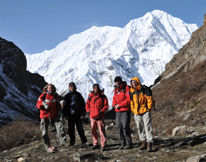
While doing trek in the khumbu region, we will witness the different views of mountains such as Kwangde, Thamserku, Nuptse, Lhotse, Ama Dablam, the "horse saddle" of Kanteiga and of course the summit of Everest itself. We take a short rest for a while and it allows us little time for acclimatization. Here, you prepare yourself to explore the ascent of kalapatthar which is an altitude of 5545m. While climbing down from Lobuche, you will see some glacial moraine until the peak comes into view. Finally, you will be witnessing the north face of Mt. Everest . We return through a different route through Panboche to Lukla. We catch a flight for Kathmandu from Lukla.
micke, USA