Manalsu Circuit Trekking
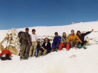 MANASLU TREKKING IN NEPAL (LARKE PASS)
This trek is one of the fines trek in Nepal . It brings you face to face with the northern boarder of Nepal with Tibet . Before dropping into the Marshyandi valley, we cross the Larkya-La pass.
This area is recently opened up for trekking. Trekking in this region offers you a life time experience. The trails are relatively empty of tourist. You see the culture and tradition of the people intact. The scenery it offers is fascinating and magnificent. We follow the route that covers the Himalayan buffs.
You see the Himalchuli in the northern side. Exploring village gives you the first hand experience as very few tourists have reached in this place. The life style of the village is still same even after a decade. We start this trek from Gorkha, and then the trail goes through the primitive villages. People are very shy and innocent in these places. They may run away if they saw you capturing them in the camera. The trail continues towards Namru through the Ghap village.
Highlight sights of Manalsu Circuit Trekking:
Ganesh Himal I – 7406m, Ganesh Himal II - 7150m, Ganesh III- 7130m, Ganesh IV – 6950m, Lampu 6480m, Pama Himal 6300m, Chhajung Himal 5525m, Pang Phuchin 6335m, Budda Himal 6672m, Himal Chuli 7893m, Ngadi Chuli 7871m, Manaslu 8163m, Phungi 6398m, Simnag Himal 5557m, Kang Guru 7010m, Lamjung
Facts of Manalsu Circuit Trekking:
| Country | Nepal |
| Trekking Destinatin: | Manalsu Circuit Trekking |
| Trekking Starts in: | Arughat |
| Trekking Ends in: | Bhulbule |
| Trip Duration: | 23 Days |
| Activities: | Trekking & Walking, Cultural Tours & Sightseeing |
| Culture: | Majority of Tibetan, Gurung, Magar, Chhetri. |
| Transportation: | Private vehicle as per itinerary | Kathmandu - Arughat by bus. Bhulbule - Kathmandu by bus |
| Accommodation: | 4 Nights in Kathmandu, 18 Nights in trekking lodge. |
| Trekking grade: | Challenge & Hard |
| Max. Altitude: | 5,213m. Lharke pass |
| Best season in Nepal: | Mar, Apr, May, Sep, Oct & Nov |
| Mode of Trekking: | Camping |
| Group Size: | Min 02 PAX, Max 12 PAX |
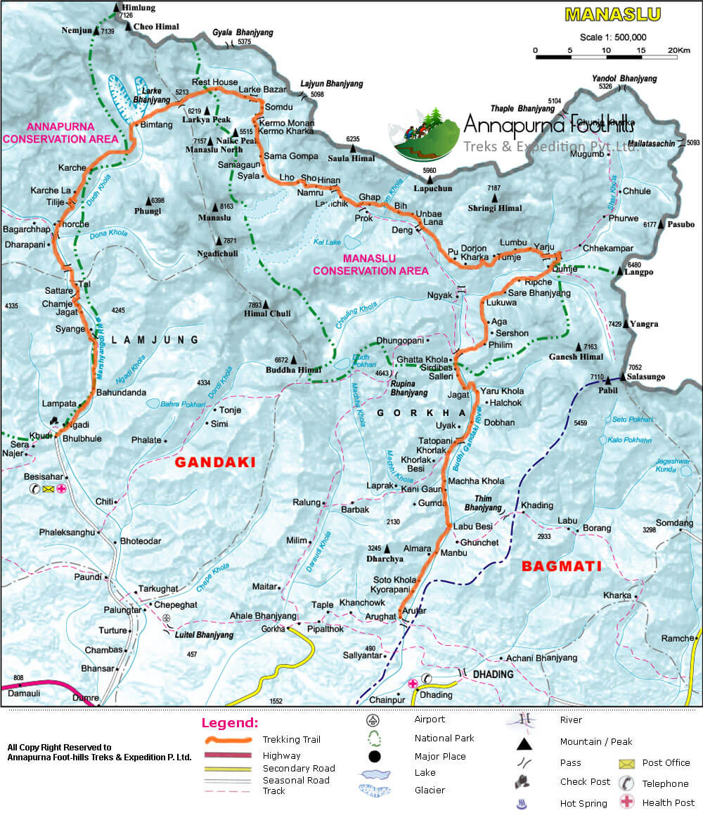
Map of Manalsu Circuit Trekking:
Detail Itinerary for Manalsu Circuit Trekking
| Days | Day to Day Activities |
|---|---|
| 01 |
Arrival in Kathmandu
Flying to Kathmandu along the northern border of Nepal on a clear day is in itself an exciting and memorable experience. As you fly, the panoramic view of snow-capped Annapurna mountain range greets your sight. After the completion of Visa formalities, you have to come downstairs to collect Luggage and proceed to outside from terminal Building. Please look at your Printed Name and Our Company Signboard Annapurna Foothills Treks & Exp and follow them. Meet our representative and then you will be transferred to hotel. You will be served free welcome drinks, tea or coffee or juice at the time of check in. The Managing Director or The Manager of company will meet you in hotel and will brief about the trip. You should clear your dues before we proceed for the trip. You are free to relax or explore around the city in the very first day. |
| 02 |
Sight seeing Kathmandu
After the breakfast in the morning, our city guide will come to the hotel with vehicles and then we leave hotel to visit Kathmandu Darbar Square, the house of living Goddess Kumari, the ferocious Kal Bhairab, The Red Monkey God and hundreds of erotic carvings. Swayambhunath is the worlds most glorious Buddhist Chaityas.It is said to be 2000 years old. Boudhanath is a huge Buddhist stupa located about 7 km east of Thamel. It stands on a massive mandala style platform and has features similar to the Swayambhunath, though it is bigger than Swayambhunath in size. It is said that this stupa was built during the 5th Century. Every year, Thousands of pilgrims from Nepal and neighboring countries visit Boudhanath, particularly in winter and Pashupatinath temple. Pashupatinath temple is one of the biggest Hindu temples. |
| 03 |
Drive Kathamndu to Arughat (606m)
It is about a 6 - 8 hour drive to Arughat, a large prosperous bazaar in central Nepal (part of the drive to Arughat is along a rough road). Once at Arughat, we'll meet our local staff and porters and camp for the night on the banks of the Buri Gandaki River. |
| 04 |
Arughat to Soti Khola (712m)
We begin the trek past monkey-filled forests to reach the hamlet of Sante Bazaar. The banks of the Buri Gandaki now become steeper and the walking is more difficult as the trail crosses the Arket Khola and climbs through fields and over a rocky outcrop. We descend to a high cascading waterfall, then continue to a camp by the Sati Khola at 710m. (5-6 hours.) |
| 05 |
Soti Khola to Machha Khola (883m)
After breakfast, we cross the bridge and climb up onto a ridge above the huge rapids of the Buri Gandaki. The trail continues, climbing over a big rock and crossing a log bridge, before it eventually descends back down to the banks of the Buri Gandaki. We trek up again on a steep rocky trail clinging to the side of a cliff, then up and around to the Gurung village of Labishe (880m) and beyond to the river. (4-5 hours.) |
| 06 |
Machha Khola to Jagat (1,415m)
Today we continue following the course of the Buri Gandaki, climbing and descending many ridges. Eventually the river valley widens and we follow a good trail to Jagat (1,415m), a compact village with a beautiful flagstone square. We camp below the village by the Bhalu Khola. (5-6 hours.) |
| 07 |
Jagat to Beyond Philim (1,606m)
The trail now crosses the river and climbs over a rocky ridge to the settlement of Salleri. We continue up the side of a cliff, then descend to Setibas, where several mani walls indicate we are now entering a region of Tibetan influence. The trail continues up to the stone houses of Ghatta Khola, then heads over to the east side of the river, passing through Philim. Our camp for the night is about one hour beyond Philim. (5-6 hours.) |
| 08 |
Beyond Philim to Deng (1,804m)
Beyond Philim, the trail enters a steep uninhabited gorge. We descend grassy slopes and cross the Buri Gandaki on a wooden cantilever bridge where the river is at its narrowest. The trail now hangs on a cliff, climbing over ridges and descending back to the river. The valley finally widens and it's a pleasant walk through bamboo forests to the tiny village of Deng. We have now succeeded in crossing the main Himalayan Range, and the trail follows the Buri Gandaki Valley as it turns from north-south to east-west. This region is known as Kutang and is inhabited primarily by Gurungs who practice Buddhism. (5 hours.) |
| 09 |
Deng to Namrung (2,670m)
We head west up the Buri Gandaki Valley, contouring up and out of the canyon, then drop into the Shringi Khola Valley. More ups and downs eventually bring us to Ghap, a village of five or six stone houses. The mani wall in Ghap has particularly elegant carvings, many of which depict the Buddha in various meditative poses and others of the Tibetan saint Milarepa, who is said to have travelled and meditated in this valley. We head into the woods through fir trees alive with birdlife, including the monal, or impeyan pheasant, Nepal's colorful national bird. On the north side of the river is the Tom Khola, flowing in a deep gorge from Tibet, almost doubling the flow of the Buri Gandaki. There is a lot of trading between villages in this region and those higher in the valley and also with Tibet. In the middle of the forest we cross a wooden bridge spanning the Buri Gandaki, then make a long climb through bamboo and rhododendron forests to Namrung (2,670m). This village has lovely stone houses and a police checkpost that controls access to the upper part of the valley. (About 7 hours.) |
| 10 |
Namrung to Shya (3,530m)
Beyond Namrung we enter the Nupri Region, inhabited by descendants of Tibetan immigrants. After passing through the villages of Barcham, Li, and Sho, we begin to get spectacular views of Manaslu, Manaslu North, and Naike Peak at the head of the valley. The trail finally emerges onto a plateau at Shya (3,530m), one of the most spectacular view sites in the Himalayas, with wide vistas of Himal Chuli, Ngadi Chuli (Peak 29), and Manaslu. (About 5 hours.) |
| 11 |
Shya to Samagaon (3,541m)
From Shya, the trail crosses a ridge, enters and then exits a side canyon, then descends onto a rock-strewn moraine. From here we clamber across the boulders to emerge onto a ridge overlooking the extensive pastures and fields of Samagaon (3,541m). We walk through the busy village up to its gompa and our campsite, which is located just beyond. (2-3 hours.) |
| 12 |
Acclimatisation day at Samagaon (3,541m)
A day to relax or take gentle day walks in the area. We can walk up to the monastery in the afternoon, or visit the local school, with which we developed links on our Manaslu 2008 expedition. |
| 13 |
Samagaon to Samdo (3,872m)
Revitalised following our rest day, we descend to the Buri Gandaki, which has now turned north again, and follow the trail to the Larkya La. Winding on a shelf above the river, the trail is at first good and easy, then gets rougher as it reaches a ridge where yak trains have ground it up. We continue to Samdo (3,872m), which is nestled behind a ridge. (3-4 hours.) |
| 14 |
Acclimatisation day at Samdo (3,872m)
It is necessary for us to have another acclimatisation day today, before camping at 4,500m tomorrow - just over 600m higher and then crossing the Larkya La (5,213m) the day after that. We like to spend acclimatisation days with 'active pottering' - the aim being to use our respiratory system, but not to over exert ourselves. |
| 15 |
Samdo to Larkya Phedi (4,494m)
We descend on a wide, gentle trail to the river, then begin the climb toward the Larkya La. We climb in and out of a huge gorge and contour to the only shelter on the route to the pass, a rest house at 4,480m with views of the Larkya Glacier. (5-6 hours.) |
| 16 |
Cross the Larkya La (5,213m) Bimthang
The crossing of the Larkya La (5,213m) is the high point of the Manaslu Circuit. Today we'll skirt a moraine and climb up a ridge, eventually ending up on top of the moraine at 4,695m. We descend a bit, then make the final steep climb to the pass at 5,213m. From here the views are tremendous: Himlung Himal (7,125m, Cheo Himal (6,820m, Kang Guru (6,980m, and Annapurna II (7,940m. The descent follows the top of the moraine to the west, then drops steeply and traverses scree slopes. We make a long set of steep, rough switchbacks to cross the moraine. There is a final long, steep, slippery descent on loose gravel to another grassy moraine at 4,450m. We head down to a large meadow and a rest house at Bimtang (3,720m), situated in a huge valley surrounded by high peaks. (About 8-9 hours.) |
| 17 |
Bimthang to Gho (2,568m)
We descend through pine and rhododendron forests to Hompuk and down to a fork of the Dudh Khola. The trail continues to Gho. |
| 18 |
Gho to Dharapani (2,006m)
In the morning we cross the Dudh Khola and trek along the riverbank. As the trail descends through scrub forests, the wall of the Marsyandi Valley looms larger, and finally the houses of Dharapani become visible. At the village of Thonje, we go through a police checkpoint, then continue to Dharapani (2,006m). (About 4 hours). |
| 19 |
Dharapani to Syange (1,194m)
The remainder of our trek follows trails used on the first few days of the Annapurna Circuit Trek. We descend to the Marsyandi River and cross the suspension bridge. We then climb up and away from the river and hike through a broad, flat valley to the village of Tal (1,675m), situated at the foot of a large waterfall. The trail continues on to Chyamje, recrossing the river once again. It then descends through forests of rhododendron and pine to Syange, where we camp for the night. |
| 20 |
Syange to Bhulbule (1,314m)
Climb up from the river to Bahundanda (1,310m), then continue to Bhulbule (1,314m). |
| 21 |
Drive Bhulbule to Kathmandu
It is a 6-7 hour drive to Kathmandu. Upon arrival in the city we transfer to the Summit Hotel. The afternoon can be spent exploring Kathmandu and visiting some of the temples, or simply browsing bookshops and shopping in the Thamel area. The team may choose to eat at the Summit Hotel tonight or in town at one of the many excellent restaurants. |
| 22 |
Sight seeing in Kathmandu
After breakfast, our city guide reaches in Hotel with Vehicles, then we drive to Bhaktapur Durbar Square. Bhaktapur is one of the oldest cities in Kathmandu valley. It is well known as Living Museum. Old brick paved enclave of old Royal palace, Nyathapola Temple, Datatriya temple, exquisite artwork offers a picture of the grandeur of medieval Nepal. And Patan is located 7 km away from Kathmandu, this city has many 15th to 17th century, Hindu and Buddhist, monuments built during the Malla dynasty. The most important area with many monuments is the Patan Durbar Square. (Culture program) Over night stay at Hotel. |
| 23 |
Depart Kathmandu:
Our Nepalese support team will take you to the airport for your flight back to home. (Or stay longer for short tours such as game drive at National parks, rafting, Tibet tours, mountain biking etc). |
Note:
The monsoon starts in July to August in Nepal. Nevertheless, there are few rain shadow areas such as Upper Mustang, Upper Manang, Rara Lake, Langtang valley, Everest Gokyo valley and Dolpo Region where we can go for trek even in monsoon. Due to the presence of huge mountains in this area, the rain cloud can’t go there and it remains unaffected by the monsoon. However, we suggest you to carry raincoat and insect repellents.
IMPORTANT NOTE:
The safety and security of clients is a matter of great importance for us. All of our trips are led by qualified professional government license holder guides and they have received adequate training from the government of Nepal. We always carry first aid kits in our trip. Out duty is to work hard for you safety and comfort, no matter where we go. Therefore, we work very honestly to provide you the Himalayan experience that suits your needs. Please feel free to put forward your queries for making your trip more significant and memorable.
Manalsu Circuit Trekking Service Includes
- Transportation from airport-hotel-airport
- 4 nights stay in hotel on B/B plan.( hotel category are of four stars) or according the program (Click for Hotel)
- Meals prepared by our cook
- Foam mattresses
- Sleeping bag
- Sleeping tents, dining tent & toilet tent
- Wages Sherpa's, porters, cook and sirdar
- Insurance's Sherpa's, porters, cook and sirdar
- All transportation mention above the program, costs of staff, equipment and food
- All trek permits, park fees and local taxes. Trek Permit & Any required permits or Official Documentation
- Table and chair
- Round trip land Transporation ( Hotel – Domestic Airport – Hotel ) by Car / Van / Hiace and tourist bus
- Transportations Kathmandu Gorkha or Arughat
Manalsu Circuit Trekking Service Excludes
- International roundtrip Airfare
- Nepal visa fee: US$ 30
- Travel & Health Insurance- Emergency Helicopter Rescue Insurance (Most recommended).
- Any meals ( Lunch & Dinner) in Kathmandu – keep $ 8 to 12 per meal in Tourist Restaurant.
- Any Alcoholic Drinks, Cold Drinks, Mineral Water, Beverages,
- Tips for guide, Cook, Sherpa and Porters Yak men and Donkey men ( mandatory)
- Any Other Cost, which is not mentioned in Cost Includes Items as above
- Unforeseen Cost such as Flight Cancellation or Delayed, Sick in Trek, and Helicopter rescue in Trek, Cost due to bad weather etc which is out of our control
- Guided sightseeing around Kathmandu Valley with all applicable entrance fees as per our itinerary. (Click for tour in Kathamndu).
Client Testimonials
Namadste!
While doing trek in the khumbu region, we will witness the different views of mountains such as Kwangde, Thamserku, Nuptse, Lhotse, Ama Dablam, the "horse saddle" of Kanteiga and of course the summit of Everest itself. We take a short rest for a while and it allows us little time for acclimatization. Here, you prepare yourself to explore the ascent of kalapatthar which is an altitude of 5545m. While climbing down from Lobuche, you will see some glacial moraine until the peak comes into view. Finally, you will be witnessing the north face of Mt. Everest . We return through a different route through Panboche to Lukla. We catch a flight for Kathmandu from Lukla.
micke, USA