Lower Dolpo Trekking
 The permission to trek in Dolpo region was granted after 1989 only. This region lies to the west of Kaligadaki valley. Dolpo is situated inside the shey-phoksundo national par in mid western part of Nepal, behind Dhaulagiri massif towards Tibetan plateau. It offers opportunities to visit ancient villages, high passes, beautiful lakes, isolated Buddhist monasteries and also to experience the vast array of wildlife inhabitants. This remains a truly isolated corner of Nepal, time has stood still here for centuries as inhabitants of Tibetan stock continue to live, cultivate and trade.
Most treks in Dolpo take only 30-40 days. September to November is the best season to visit this place. Short Dolpo treks are possible only by flying into a air strip to Jumla.
The extreme landscape of upper Dolpo lies in the northwestern part of Nepal. The route begins by meandering through pine and cedar forest with the view of massive Dhaulagiri range in the background. Beyond the Jangla Bhanjyang pass, the Dolpo entrance starts. The snow-capped peaks lay at the head of the valley and Tibetan plateau desolates beyond. This area is protected by rain and trading with Tibet has become the main survival strategy of the local inhabitants. Buddhist Bonpo sect is our momentous destination. As the most remote and least developed district in Nepal, this trek is reserved for those with a true sense of adventure.
The landscape resembles with the Tibetan plateau probably due to its geographical location, rain shadow area of Himalayas. The people are very pleasant by nature and their language carries Buddhist descent. They follow the pre-Buddhist Bon religion. The elevation of the trails is from 1650 meters (5,412ft) to 5136 meters (16,846ft) above sea level.
Highlight sights of Lower Dolpo Trekking:
Sisne Himal 5849m, Api Himal 7132m, Api West 7100m, , Saipal 7031m, Rakshya Uda 6593m, Kandey Himchuli 6227m, Buraburi 5387m, Tsokalpo Khang 6556m, Wedge peak 6139m. Kangchune 6443m, Bijala Himchuli 6386m, Paltathumba 6157m, Milch Berg 5992m, Hanging Peak 6500m, Kang Peak 6224m, Yaja Peak 5962m. And Dhaulagri rage.
Facts of Lower Dolpo Trekking:
| Country | Nepal |
| Trekking Destinatin: | Lower Dolpo Trekking |
| Trekking Starts in: | Jumla |
| Trekking Ends in: | Juphal |
| Trip Duration: | 20 Days |
| Activities: | Trekking & Walking, Cultural Tours & Sightseeing |
| Culture: | Different Community with majority of Gurungs, Magars, Chhetri, Brahamn, Tibetan |
| Transportation: | Private vehicle as per itinerary | Kathmandu - Nepalgunj - Jumla, Juphal - Nepalgunj - Kathmandu flight, |
| Accommodation: | 4 Nights in Kathmandu, 2 Nights in Nepalgunj, 13 Nights in trekking lodge. |
| Trekking grade: | Challenge |
| Max. Altitude: | 5115m |
| Best season in Nepal: | Mar, Apr, May, Sep, Oct & Nov |
| Mode of Trekking: | Camping |
| Group Size: | Min 02 PAX, Max 12 PAX |
Lower Dolpo Trekking:
Detail Itinerary for Lower Dolpo Trekking
| Days | Day to Day Activities |
|---|---|
| 01 |
Arrival in Kathmandu
Upon your arrival at international airport, After the completion of Visa formalities you have to come downstairs to collect Luggage and proceed to outside from terminal Building. Please look at your Printed Name and Our Company Signboard Annapurna Foothills Treks & Exp and follow them. Meet our representative; you will be transferred to your hotel in Kathmandu .. You should clear your dues before we proceed for the trip. You are free to relax or explore around the city in the very first day. |
| 02 |
Sight seeing Kathmandu
After breakfast, we visit Bodhanath, the Stupa of a Million Dew-Drops. We circumambulate the stupa with monks and devotees. then we Visit Pashupatinath , Nepal 's most sacred Hindu temple dedicated to Lord Shiva, the destroyer. We watch Hindu cremation along the banks of the Bagmati River . After visiting Pashupatinath, we drive to Bhaktapur - the City of Devotees . There is a one big museum in Bhaktapur which is famous for temples, palaces and houses dating back several centuries. Drive back to Kathmandu . Overnight stay at hotel |
| 03 |
Kathmandu to Nepalgunj
We have to fly to Nepalgunj from Kathmandu. Nepalgunj is the jumping-off place for flights and busses throughout western Nepal. Unfortunately there is no connecting flight to Jumla (the start of our trek), so we will spend the night here. |
| 04 |
Nepalgunj to Jumla
An early morning plane will take us to the town of Jumla, which lies on the banks of the Tila Khola river at 2370 meter. Jumla is one of the highest rice-growing areas of the world, where the unique ‘red’-rice is grown. We will meet our trekking crew today and make the final preparations for our camping-trek. |
| 05 |
Jumla to Gothi Chaur (2500m)
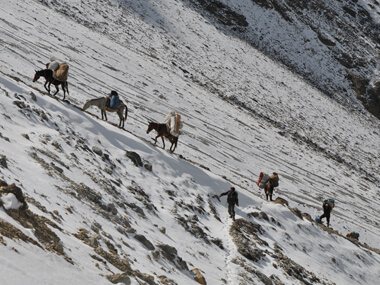
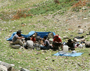
From Jumla our trail leads past several water-driven mills before dropping to the confluence of the Tila Khola and the Chaudhabise Khola. We cross both rivers on a cantilever bridge which looks like it is held together by giant clothes pegs. From here our trail climbs gently alongside rice terraces to the village of Dochal Ghara at 2530 meter. From here we follow the trail through a forest of maples and walnuts to a meadow. In season the wildflowers seen here include cinquefoils, terrestrial orchids, forget-me-nots, mints, buttercups, primulas, edelweiss and gentians. Beyond the meadow the trail climbs to a rocky cairn at Pattyata Lagna (2830m), and then descends into a magnificent alpine amphitheatre towards Gothi Chaur close to the stream at the bottom of the valley. At the spring here there are some 13th century Malla dynasty stone carvings. We set up camp close to the river (5 hrs). |
| 06 |
Gothi Chaur to Naphukana (3080m)
We will re-enter the Tila river valley and follow this river slowly to its source. After ascending through fields of barley and buckwheat we arrive at the trail junction at Muni Sangu, a small settlement where we can see peculiar carved wooden faces, called dok-pa and are supposed to offer protection from evil spirits. These faces can be seen throughout the whole Dolpo region. We stay on the southern side of the river from here as the valley slowly becomes narrower and follow our way to Changrikot (a series of houses built into the hillside on the opposite side of the river at 2900m). The trail then finally crosses the river and climbs towards the grey stone houses of Chotra (3010m). The village has typical mani walls (walls containing stones carved with Tibetan Buddhist prayers) and a kani (arch, decorated with paintings on the inside) over the trail. A short distance from here is the Tibetan settlement of Naphukana where we will make our camp (6 hrs). |
| 07 |
Naphukana to Balasa (3110m)
The trail becomes steeper today as it climbs past rocky fields to forests of oaks and birch trees strangled with Spanish moss. The climb will end at the Mauri lagna (‘honey pass’) at 3820 meter. From this pass we have good views of the snowy peaks of Gutumba (5608m) and Mataumba (5767m) to the north-east and Bhalu Himal (5460m) to the south. We will descent from here to the Bheri valley to the large Khampa settlement of Chaurikot at 3060 meter. A short time past this village there are some excellent campsites alongside the trail (5 hrs). |
| 08 |
Balasa to Kaigaon (2610m)
We will continue our trek through walnut forests; the local people seldom eat the nuts but use them as a source for cooking oil. We slowly descend to the village of Rimi at 2890 meter, where the amusing faces of the dok-pa peek at us from the tops of houses. After crossing the stream we will arrive in Kaigaon, where we will find the first shop since leaving Jumla (3-4 hrs). |
| 09 |
Kaigaon to Toijem (2920m)
We follow the west bank of the Bheri river and climb slowly up leaving the river deep below us. The trail stays high above the river and continues to the confluence where the Jagdula and Garpung Kholas join to form the Bheri. We then drop to the Jagdula Khola river and cross it on stones to our campsite near the army post at Toijem (5 hrs). |
| 10 |
Toijem to Kagmara Phedi (4000m)
Today we follow the trail up the western side of the Garpung Khola river to about 3650 meter, after which we cross it and continue upstream on the eastern side. The valley narrows and the river becomes a series of waterfalls as the trail climbs to a moraine at 3900 meter. We will make a high camp in the boulders at Kagmara Phedi. The panoramic views of the peaks from here are sensational. Wildflowers are of the hardy alpine species, including blue poppies, buttercups, mint, gentians and puffballs. Among the birds here you may sight snow pigeons, redstarts, ravens and griffons. This is also an excellent place to spot blue sheep (6 hrs). |
| 11 |
Kamarga Phedi to Lasa (4060m)
We start early to climb alongside the Kagmara Glacier to Kagmara La pass at 5115 meter. Then we descend about 900 meter along a stream into the Pungmo valley. On this side of the pass there are sweeping scree slopes and massive rock formations that contrast with the vertical uplifts and thrusts of the southern side. We descend further to Lasa, a shepherds’ camp at about 4060m (7 hrs). |
| 12 |
Lasa to Sumduwa (3100m)
The trail stays high above the stream, which eventually becomes the Pungmo Khola river. The route enters birch and juniper forests, which give away to blue pines as the trail crosses the river on a wooden bridge. The route continues through barley fields to the fortress-like village of Pungmo. From here we continue our way downstream to the school at Sumduwa and descend to a camp on the banks of the Phoksumdo Khola (5 hrs). |
| 13 |
Sumduwa to Phoksumdo Lake (3730m)
We will join the direct trail to Phoksumdo lake today climbing through forests of big cedars on to Palam (3710m), a winter settlement used by the people of the Ringmo village. The entrance station for the Shey Phoksumdo National Park is at the south end of the village. The route then descends on switchbacks through open country to an elevation of 3300 meter, and then starts up another set of dusty switchbacks to a ridge at 3780 meter to the highest waterfall in Nepal (200 meter high). Our route then continues on to Ringmo village, a picturesque settlement of flat-roofed stone houses with lots of mani walls. Just below Ringmo we cross a bridge and follow the trail to Phoksumdo Lake, where we camp at the national park camping grounds west of the lake (6 hrs). |
| 14 |
Phoksumdo Lake
Today we rest to admire the beauty of this great lake. We visit nearby villages inhabited by Bon and Buddhist Settlers and can make a short excursion to the white Pal Sentan Thasoon Chholing Gompa, a Bon-po gompa overlooking the lake, which is said to be build 60 generations ago. |
| 15 |
Phoksumdo Lake to Renje (3010m)
We back track our path to Ringmo village and continue past Palam to the Suli Gaad valley, following the stream originating from the Phoksumdo Lake. After a descent of almost 900 meters we will arrive in the small village of Renje, which consists of 9 houses on the side of the river. Here we will find a good campsite about 5 minutes from the village (5 hrs). |
| 16 |
Renje to Chepka (2670m)
Our route follows several ups and downs alongside the river through forests of firs and larches as it continues downstream. The trail then becomes a collection of rocks and sticks forming a dyke along the river bank. We will set up camp beside a huge rock in a walnut grove about 20 minutes away from Chepka. (4-5 hrs). |
| 17 |
Chepka to Juphal (2354m)
Today we walk to the region famous for its lotus-like plant called chuk, which is used to make vinegar and medicines. We pass through the villages of Ankhe, Rahagaon and Parela, meaning 'eye', 'eyebrow' and 'eyelash' respectively. We keep walking downstream following the river to Dunai. From here we ascend to Juphal climbing through wide meadows. In Juphal we will spend the night in one of its hotels where a well deserved hot shower awaits us (7 hrs). |
| 18 |
Juphal to Nepalgunj
We fly to Nepalgunj today and connect with our flight back to Kathmandu next day. |
| 19 |
Nepalgunj to Kathmandu
We take a flight from Jumla to Nepalgunj. On reaching Nepalgunj, we return to Kathmandu on the next available flight. You can spend the rest of the day shopping and general sightseeing. |
| 20 |
Kathmandu
Departure from Kathmandu. |
Note:
The monsoon starts in July to August in Nepal. Nevertheless, there are few rain shadow areas such as Upper Mustang, Upper Manang, Rara Lake, Langtang valley, Everest Gokyo valley and Dolpo Region where we can go for trek even in monsoon. Due to the presence of huge mountains in this area, the rain cloud can’t go there and it remains unaffected by the monsoon. However, we suggest you to carry raincoat and insect repellents.
IMPORTANT NOTE:
The safety and security of clients is a matter of great importance for us. All of our trips are led by qualified professional government license holder guides and they have received adequate training from the government of Nepal. We always carry first aid kits in our trip. Out duty is to work hard for you safety and comfort, no matter where we go. Therefore, we work very honestly to provide you the Himalayan experience that suits your needs. Please feel free to put forward your queries for making your trip more significant and memorable.
Lower Dolpo Trekking Service Includes
- 4 nights hotel in Kathmandu with Bed & Breakfast. (Click for Hotel)
- Trekking permit fee of Rara and Dolpa region & National Park fee
- Equipment: Trekking tents, Dining tent, Kitchen Tent, Toilet Tent, Table and chairs, Mattresses during the trekking & Peak climbing
- National Park fee Rara and Dolpo region
- Food: Food for trekking & Peak climbing (Breakfast, lunch, dinner)
- Staff: 1 Guide, 1 Cook, 1 Kitchen & necessary porters
- Local transportation Airport - Hotel - Airport
- Flight Kathmandu - Nepalgunj-Jumla and Dolpa-Nepalgunja-Kathmandu
- Trekking crews of insurance
- Trekking allowance, food allowance for trekking crews
- Our service charge
Lower Dolpo Trekking Service Excludes
- PERSONAL equipment for Trekking
- Personal Insurance for travel to Nepal
- Lunch & dinner in Kathmandu
- Emergency Rescue evacuation
- Personal expenses
- Tipping (Tips)
- Bar bills & Beverages
- Departures taxes
- Guided sightseeing around Kathmandu Valley with all applicable entrance fees as per our itinerary. (Click for tour in Kathamndu).
Client Testimonials
Namadste!
While doing trek in the khumbu region, we will witness the different views of mountains such as Kwangde, Thamserku, Nuptse, Lhotse, Ama Dablam, the "horse saddle" of Kanteiga and of course the summit of Everest itself. We take a short rest for a while and it allows us little time for acclimatization. Here, you prepare yourself to explore the ascent of kalapatthar which is an altitude of 5545m. While climbing down from Lobuche, you will see some glacial moraine until the peak comes into view. Finally, you will be witnessing the north face of Mt. Everest . We return through a different route through Panboche to Lukla. We catch a flight for Kathmandu from Lukla.
micke, USA